Please report any broken links or trouble you might come across to the Webmaster. Please take a moment to let us know so that we can correct any problems and make your visit as enjoyable and as informative as possible.


NavSource Online: Army Ship Photo Archive

Bataan


Towboat:
  • Built in 1943 for the Defense Plant Corp (DPC 607) at Cargill, Port Savage, MN.
  • Launched in 1943
  • Accepted by the Defense Plant Corp. in October 1943
  • Delivered to Federal Barge Lines in 1943
  • Leased to Inland Waterways Corporation for the duration of World War II
  • Sold at the end of World War II to Standard Oil Ohio
  • Renamed SOHIO Latonia in May 1947
  • Resold in 1949, renamed Orleanian
  • Retired from service in 1965
  • Final Disposition, fate unknown
    Specifications:
    Displacement 1016 t.
    Length 180'
    Beam 52'
    Hull Depth unknown
    Draft 11'
    Speed unknown
    Crew unknown
    Propulsion
    two reciprocating steam engines
    two propellers

    Click On Image
    For Full Size Image
    Size Image Description Source
    Bataan
    303021002
    358k
    Namesake
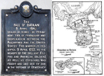
    Bataan - A peninsula 25 miles long and 20 miles wide at its base that forms the west side of Manila Bay on the island of Luzon in the Philippines (NS022933a). Following the Japanese landings on Luzon in mid-December 1941 and their successful advance toward Manila, General Douglas MacArthur, Commander, United States Army Forces in the Far East, ordered his forces to withdraw into the Bataan peninsula on 24 December. Just over two weeks later, on 9 January, elements of Lieutenant General Homma Masaharu's 14th Army attacked the American and Filipino troops defending the peninsula. Although driven back from their initial defensive positions, the American and Filipino troops held their secondary defensive line, forcing Homma to call off his offensive on 8 February. Japanese attempts to outflank the defensive lines through amphibious landings on the peninsula also failed.

    The defenders of Bataan, however, were blockaded and isolated by the surrounding Japanese air and naval forces. Malnutrition and disease weakened the troops and, when they realized no Allied help was coming from Pearl Harbor or Australia, their morale plummeted as well. Meanwhile, Japanese reinforcements strengthened Homma's forces, and he launched a second offensive on 3 April. This attack, coming three weeks after MacArthur left for Australia, broke through the defensive lines and defeated an American counter-attack. On 9 April, in order to prevent unnecessary slaughter, the remaining 78,000 defenders surrendered. They were forced to march more than 60 miles (some 100 km) from Bataan to Capas, Tarlac, in what became known as the Bataan Death March. About 2,000 men escaped from Bataan to the fortified island of Corregidor, where they held out against the Japanese air and artillery bombardment until themselves surrendering on 6 May
    Photo - Fall of Bataan historical marker - Photo by CC BY-SA 3.0 Eugene Alvin Villar (seav) via Wikimedia Commons
    Map - Situation map, January - April 1942, of Bataan Peninsula on the Luzon Island, Republic of the Philippines - Corregidor.org

    Tommy Trampp
    Bataan
    303021001
    108k Bataan moored to a riverbank, circa 1943, location unknown
    University of Wisconsin-Madison LaCrosse Historic Steamboat Photographs
    John Spivey

    There is no history available for Bataan at NavSource

    Back To The Navsource Photo Archives Main Page Back To The US Army Ship Index Back To The US Army Towboat Index
    Comments, Suggestions, E-mail Webmaster.
    This page is created and maintained by Gary P. Priolo
    All pages copyright NavSource Naval History
    Last Updated 28 October 2022