Please report any broken links or trouble you might come across to the Webmaster. Please take a moment to let us know so that we can correct any problems and make your visit as enjoyable and as informative as possible.
NavSource Online: Service Ship Photo Archive
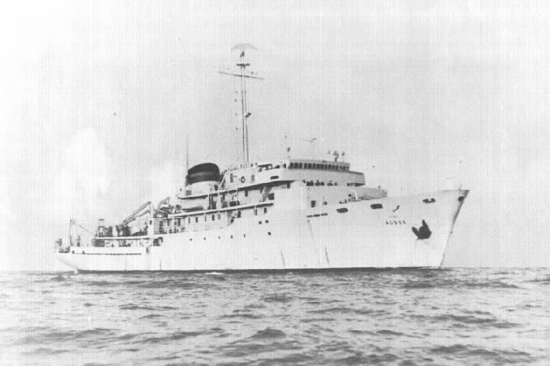
USNS Silas Bent (T-AGS-26)
Introduction Brochure
Naval Oceanographic Office pub. dated 11 February 1966

INTRODUCTION
USNS SILAS BENT (T-AGS 26) is the first of a new class of oceanographic Survey ships built for the U.S. Navy. Operated by the Military Sea Transportation Service under the technical control of the U. S. Naval Oceanographic Office, she has accommodations for 44 members of the crew and 34 scientists. Special features include anti-roll tanks to improve stability, a 350 shaft-horsepower trainable and retractable bow propulsion unit to assist station-keeping, a gas turbine to power the main motor or bow thruster during ultra-quiet ship operations, an ice-strengthened hull, and sea chests for special transducers.
SHIPBOARD SURVEY SYSTEM
SILAS BENT is equipped with the latest in navigation, communication, and meteorological facilities and can conduct oceanographic surveys with both conventional devices and modern electronic instrumentation. The prototype Shipboard Survey System, regarded as the most sophisticated measuring and recording system in oceanography today, has the capability of making both underway and on-station measurements. Underway, specially designed hoists, faired cables, and advanced sensors permit simultaneous measurements of both standard wide-beam (towed and hull-mounted) and stabilized narrow-beam bathymetric depth, total magnetic intensity, gravity, sea surface temperature, and seismic (sub-bottom) structure. While occupying an oceanographic station, an over-the-side-sensor package continuously measures and records depth, temperature, salinity, sound velocity, and ambient light to a maximum depth of 6100 meters. Distance-to-bottom information is also provided! when the package is within 500 feet of the ocean floor.
 COMPUTER DATA PROCESSING
The heart of the Shipboard Survey System is the Central Data Recording Subsystem where sensor data, not already in digital form, is digitized and transferred along with time, navigational inputs, etc. to an AN/UYK computer. The computer corrects, linearizes where necessary, computes, and arranges the data into the proper format for recording on magnetic tape. A paper tape punch and reader are included for duplicating or generating program tapes and introducing programs into the computer. Data outputs are displayed in alpha-numeric form on the control console, and a typewriter is available for X-Y plots of on-station variables or continous operational logs of events while underway.
DECK HANDLING EQUIPMENT
Fifteen different winches, a Bucyrus Erie H-5 hydrocrane, a 50,000 pound stressed U-Frame, hydrographic and other davits adequately handle over-the-side equipment such as heavy corers, dredges, trawls, bathythermographs, buoys, nansen bottles, current meters, and components of the Shipboard Survey System.
LABORATORIES AND WORKSHOPS
In addition, SILAS BENT is equipped with laboratories for electronic, chemical, biolgical, and geological purposes; a scientific office; survey control center; drafting room; photo-reproduction room; meteorological room; electronic and mechanical workshops; separate scientific chill and freeze spaces; and explosive and meteorological rocket magazines. There is also ample storage space, both on and below decks. Scientific and living spaces are air-conditioned, and all scientific areas are tied together with special wiring circuits and intercom systems.
MISSION OF SHIP
SILAS BENT is the first ship designed and delivered to the Navy for the primary purpose of conducting systematic multi-parameter surveys on a world-wide basis in support of Navy ASW/USW operations. A secondary mission is to provide science, industry, and the nation in general with an environmental model of the ocean.
USNS SILAS BENT - PERTINENT CHARACTERISTICS
Length: 285 feet Beam: 48 feet
COMPUTER DATA PROCESSING
The heart of the Shipboard Survey System is the Central Data Recording Subsystem where sensor data, not already in digital form, is digitized and transferred along with time, navigational inputs, etc. to an AN/UYK computer. The computer corrects, linearizes where necessary, computes, and arranges the data into the proper format for recording on magnetic tape. A paper tape punch and reader are included for duplicating or generating program tapes and introducing programs into the computer. Data outputs are displayed in alpha-numeric form on the control console, and a typewriter is available for X-Y plots of on-station variables or continous operational logs of events while underway.
DECK HANDLING EQUIPMENT
Fifteen different winches, a Bucyrus Erie H-5 hydrocrane, a 50,000 pound stressed U-Frame, hydrographic and other davits adequately handle over-the-side equipment such as heavy corers, dredges, trawls, bathythermographs, buoys, nansen bottles, current meters, and components of the Shipboard Survey System.
LABORATORIES AND WORKSHOPS
In addition, SILAS BENT is equipped with laboratories for electronic, chemical, biolgical, and geological purposes; a scientific office; survey control center; drafting room; photo-reproduction room; meteorological room; electronic and mechanical workshops; separate scientific chill and freeze spaces; and explosive and meteorological rocket magazines. There is also ample storage space, both on and below decks. Scientific and living spaces are air-conditioned, and all scientific areas are tied together with special wiring circuits and intercom systems.
MISSION OF SHIP
SILAS BENT is the first ship designed and delivered to the Navy for the primary purpose of conducting systematic multi-parameter surveys on a world-wide basis in support of Navy ASW/USW operations. A secondary mission is to provide science, industry, and the nation in general with an environmental model of the ocean.
USNS SILAS BENT - PERTINENT CHARACTERISTICS
Length: 285 feet Beam: 48 feet
Draft: 15 feet (max) Displacement: 2590 tons (full-load)
Speed: 16 kts (max) Endurance: 12,000 miles @ 12 kts
Crew: 44 Scientists: 34
Power Plant: Diesel-Electric, 3000 S.H.P., Single Screw
Electrical Power, normal operations:
(a) 440 volts AC-unregulated - 60 cps - Ship's Service
(b) 120 volts AC-unregulated - 60 cps - Ship's Service
(c) 120 volts t §% AC-regulated - 60 cps Ý §% - 20 KW
(d) 120 volts ݧ% AC-regulated - 400 cps ݧ% - 10 KW
(e) 120 volts Ý5% AC-precision - 60 cps Ý.0001% - 500 watts
Note: (a) and (b) supplied by one of three 300 KW diesel-driven generators or by a 300 KW gas-turbine driven generator.
Electrical Power, ultra-quiet ship (UQS) operations
(a) 440 and 120 volts AC-unregulated - 60 cps - 40 KW Diesel-driven, shock-cord suspended generator.
(b) 440 and 120 volts AC-unregulated - 60 cps - 40 KW 100 KWH battery-driven shock-cord suspended MG set
Navigation Equipment:
Loran-A; Loran-C; Radar (surface search);
Radio Direction Finder;
EM log;
Marine Course Computer;
Wind Direction and Speed Indicator; Gyrocompass.
Communications:
Transmitter/Receiver (2-24 mcs). Transceiver, SSB (2-30 mcs);
Receiver (2-30 mcs);
Receiver (15-650 kcs);
Receiver (long and short wave);
Radiotelephone (2-9 mcs).
Echo Sounders:
Raytheon 715; Edo 578; AN/UQN-l (2);
Electronically- stabilized Narrow Beam System.
Meteorological: Radiosonde Receiver (AN/SMQ-l); Weather-map Recorder and Transmitter.
Winches:
1 - Deep-Sea Coring w/double drum stowage (45,460 ft. of tapered wire rope and 30,000 ft. of §" wire rope).
1 - Deep-Sea Anchoring w/single drum stowage (45,460 ft. of tapered wire rope).
2 - Hydrographic (30,000 ft. of 3/16 inch wire rope or 12,000 ft. of 7-conductor cable).
1 - Hydrographic Storage & Wire Inspection.
I - Deep-Sea Storage & Wire Inspection.
3 . Electric Cable (9,000 ft. of 4-conductor cable).
2 - Bathythermograph (3,000 ft. of 3/32 inch wire rope).
1 - Intermediate (25,000 ft. Shipboard Survey System 0.38" 2-conductor cable).
1 each - Seismic Chain Hoist;
Seismic Storage Winch;
Bathymetric Chain Hoist;
Magnetometer Winch;
and Sea-Surface temperature boom (Shipboard Survey System deck equipment).
This page is created and maintained by Gary P. Priolo

|